How do you define a space enabled technology?
Manuel Ntumba (MN): Space enabled technology is intended for use in travel or activities beyond the Earth’s atmosphere, for purposes such as space flights or space exploration. Many common daily services for terrestrial use, such as weather forecasting, remote sensing, satellite navigation systems, satellite television and some long-distance communication systems, rely critically on space infrastructure.
How can space-enabled technologies play a role in the world’s food supply?
MN: Agriculture forms the basis of the world’s food supply. Global food security is affected by climate change, soil conditions, water availability, and extreme weather events. 1 in 9 people in the world have been found to be undernourished, the vast majority of whom live in developing countries, causing serious illnesses to 52 million children worldwide and resulting in up to 3.1 million deaths per year in children under five; almost half (45%) of the total.
Digital agriculture refers to the farming practices that collect, store, analyse and share electronic data and information throughout the agricultural value chain. Many technologies used in smart agriculture or digital agriculture are satellite technologies using geospatial data services. These include yield mapping, GPS guidance systems, and other applications.
Earth Observation from space using satellites is a cost-effective way to obtain unbiased and essential data about the world. Satellites provide valuable information on the state of ecosystems, which provides objective support for positive environmental action, including conservation and sustainable management of resources.
While most of the activity of the space economy comes from space-oriented countries, developing countries do not benefit as much as they could from this area. An inclusive global space economy can play a big role in accelerating sustainable social and economic development.
What are some examples of how space-enable tech can help us improve food security?
MN: Space technologies offer tools to aid in a wide range of agricultural activities, from crop monitoring, animal husbandry, and forestry, to fisheries and aquaculture. Space technologies are also helping to improve livestock management through better monitoring and identification of suitable pastures through the acquisition of satellite data. Policymakers and decision-makers use this information and precise data provided by satellites to understand trends, assess needs, and create sustainable development policies and programs in the best interest of all.
Satellite data also helps optimise crop productivity through an informed management process and more efficient use of existing resources, including land, seeds, fertilisers, plant protection agents, and water. Among these technologies, remote sensing satellites provide key data for monitoring soil, snow cover, drought, and crop development. Accurate information and analysis provided by satellites help forecast agricultural production well in advance and can be essential in anticipating and mitigating the effects of food shortages and famines.
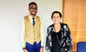 Manuel Ntumba, Executive Chairman, Tod’Aérs (pictured with Mrs. Simonetta Di Pippo, Director of the United Nations Office for Outer Space Affairs (UNOOSA) during the 28th United Nations Workshop on Space Technology for Socio-Economic Benefits)
How can we ensure equal access to space-enabled technologies for developing countries?
MN: To support the sustainable management of natural resources, environmental monitoring, and food security, the EU-Africa partnership has led to the commitment to provide European infrastructures and installations to African, Caribbean, and Pacific (ACP) countries, by improving decision-making through the use of Earth Observation (EO) data.
The Global Monitoring for Environment and Security in Africa (GMES and Africa) is a joint programme of the European Commission and the African Union Commission. It serves to strengthen and further develop infrastructures for a more coherent exploitation of Earth observation data (space and in situ), technologies, and services in support of the African Agenda 2063.
Finally, What role are businesses currently playing in this sector?
MN: Since its launch in 1993, the AfricaGIS Initiative has been developing geospatial solutions for Africa’s growth and sustainable development including in agriculture and food security. AfricaGIS partners with the GMES & Africa, on the implementation of geospatial solutions in the sector. AfricaGIS’ key strategic partners include United Nations Economic Commission for Africa (UNECA); ESRI, AIRBUS, and many more from both Africa and Europe. Maxar Technologies is also one of the key partners supporting geospatial applications, with innovative businesses and more than 50 governments to monitor global change, deliver broadband communications and advance space operations with capabilities in Space Infrastructure and Earth Intelligence.
Tod’Aérs – Transparent Organisation for Aeronautics and Space Research is a global network that brings together researchers, university professors, professionals, experts, innovators, business leaders, government diplomats, and entrepreneurs from around the world, to collaborate on sustainable research projects. Tod’Aérs is a multinational organisation promoting global sustainable development through research in geospatial and space studies – in support of the United Nations Global Goals.
To implement the vision of achieving global sustainable development through space technologies, digital transformation, and geospatial applications, Tod’Aérs is currently working in collaboration with Raissa Malu, a Member of the Presidential Panel of the African Union, and its Chair, President Felix-Antoine Tshisekedi Tshilombo, to develop a roadmap on using space technologies to support the Agenda 2063 of the African Union (AU).
GMES & Africa is currently implemented by 12 consortia involving 144 institutions in 45 African countries, covering the entire continent. GMES & Africa is particularly working to adapt data and services from the Copernicus Earth Observation Program for use in the African context to meet African needs in the development of services for food security, water, natural resources, marine, and coastal areas, meet global environmental management needs, and ensure civil security.
___
to join Manuel IN the ‘regenerate’ community, apply to become a member of meaningful business here


